import intake
import hvplot.pandas
import hvplot.xarray
import cook_inlet_catalogs as cic
import holoviews as hv
HF Radar (UAF)
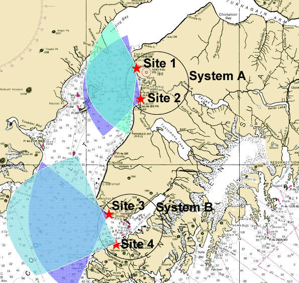
HF Radar from UAF.
Files are:
Upper Cook Inlet (System A): 2002-2003 and 2009
Lower Cook Inlet (System B): 2006-2007
Data variables available include tidally filtered and weekly averaged along with tidal constituents calculated from hourly data.
Some of the data is written up in reports:
https://espis.boem.gov/final%20reports/5009.pdf
https://www.govinfo.gov/app/details/GOVPUB-I-47b721482d69e308aec1cca9b3e51955
cat = intake.open_catalog(cic.utils.cat_path("hfradar"))
Plot all datasets in catalog
dd, ddlabels = cic.utils.combine_datasets_for_map(cat)
dd.hvplot(**cat.metadata["map"]) * ddlabels.hvplot(**cat.metadata["maplabels"])
List available datasets in the catalog
dataset_ids = list(cat)
dataset_ids
['lower-ci_system-B_2006-2007',
 'lower-ci_system-B_2006-2007_subtidal_weekly_mean',
 'lower-ci_system-B_2006-2007_tidecons',
 'lower-ci_system-B_2006_subtidal_daily_mean',
 'lower-ci_system-B_2006_subtidal_weekly_mean',
 'lower-ci_system-B_2006_tidecons',
 'upper-ci_system-A_2002-2003',
 'upper-ci_system-A_2002-2003_subtidal_weekly_mean',
 'upper-ci_system-A_2002-2003_tidecons',
 'upper-ci_system-A_2003_subtidal_daily_mean',
 'upper-ci_system-A_2003_subtidal_weekly_mean',
 'upper-ci_system-A_2003_tidecons',
 'upper-ci_system-A_2009',
 'upper-ci_system-A_2009_subtidal_weekly_mean',
 'upper-ci_system-A_2009_tidecons']
Select one dataset to investigate
try:
    dataset_id = dataset_ids[2]
except:
    dataset_id = dataset_ids[0]
print(dataset_id)

dd = cat[dataset_id].read()
dd
lower-ci_system-B_2006-2007_tidecons
<xarray.Dataset> Size: 248kB
Dimensions:      (x: 26, y: 35, ntidecons: 8, tideconvals: 4)
Coordinates:
  * ntidecons    (ntidecons) <U2 64B 'M2' 'S2' 'K2' 'K1' 'N2' 'P1' 'O1' 'Q1'
  * tideconvals  (tideconvals) <U11 176B 'major' 'minor' 'inclination' 'phase'
    lat          (x, y) float64 7kB dask.array<chunksize=(26, 35), meta=np.ndarray>
    z            float64 8B ...
  * x            (x) int64 208B 0 1 2 3 4 5 6 7 8 ... 17 18 19 20 21 22 23 24 25
  * y            (y) int64 280B 0 1 2 3 4 5 6 7 8 ... 26 27 28 29 30 31 32 33 34
    lon          (x, y) float64 7kB dask.array<chunksize=(26, 35), meta=np.ndarray>
Data variables:
tidecons (x, y, ntidecons, tideconvals) float64 233kB dask.array<chunksize=(26, 35, 8, 4), meta=np.ndarray>Plot one dataset
keys = list(cat[dataset_id].metadata["plots"].keys())
print(keys)

plots = []
for key in keys:
    plot_kwargs = cat[dataset_id].metadata["plots"][key]
    if "clim" in plot_kwargs and isinstance(plot_kwargs["clim"], list):
        plot_kwargs["clim"] = tuple(plot_kwargs["clim"])
    if "dynamic" in plot_kwargs:
        plot_kwargs["dynamic"] = False
    plots.append(cat[dataset_id].ToHvPlot(**plot_kwargs).read())
hv.Layout(plots).cols(1)
['tidecons']